Far from any coastline, in the punishing emptiness of West Antarctica, a small team of scientists huddles against the wind. The temperature hovers at -30°C, the light is perpetual and flat, and beneath their boots lies more than half a mile of solid ice. Yet what captivates them is not the surface, but the world that has remained concealed for millions of years — a landscape of buried mountains, ancient rivers, hidden lakes, and surprising geological giants now slowly coming into view.
For decades, Antarctica has been seen as a vast, uniform freezer. New discoveries, however, are revealing a far more complex and dynamic continent beneath the ice — one that holds critical clues about our planet’s past and unsettling warnings about its future.
A granite giant beneath the “Doomsday” glacier
One of the most striking recent finds lies beneath Pine Island Glacier, a neighbour to the notorious Thwaites Glacier. In 2025 and early 2026, scientists traced mysterious pink granite boulders scattered across the volcanic Hudson Mountains to their source: a massive buried granite body, roughly 100 km across and nearly 7 km thick — about half the size of Wales.
This hidden geological giant was detected through gravity measurements and detailed modelling. Its discovery solved a long-standing puzzle and is reshaping our understanding of the bedrock that supports (and sometimes destabilises) the West Antarctic Ice Sheet. Such large intrusions can influence heat flow and the way ice moves above them, adding another variable to predictions of how quickly glaciers may retreat.
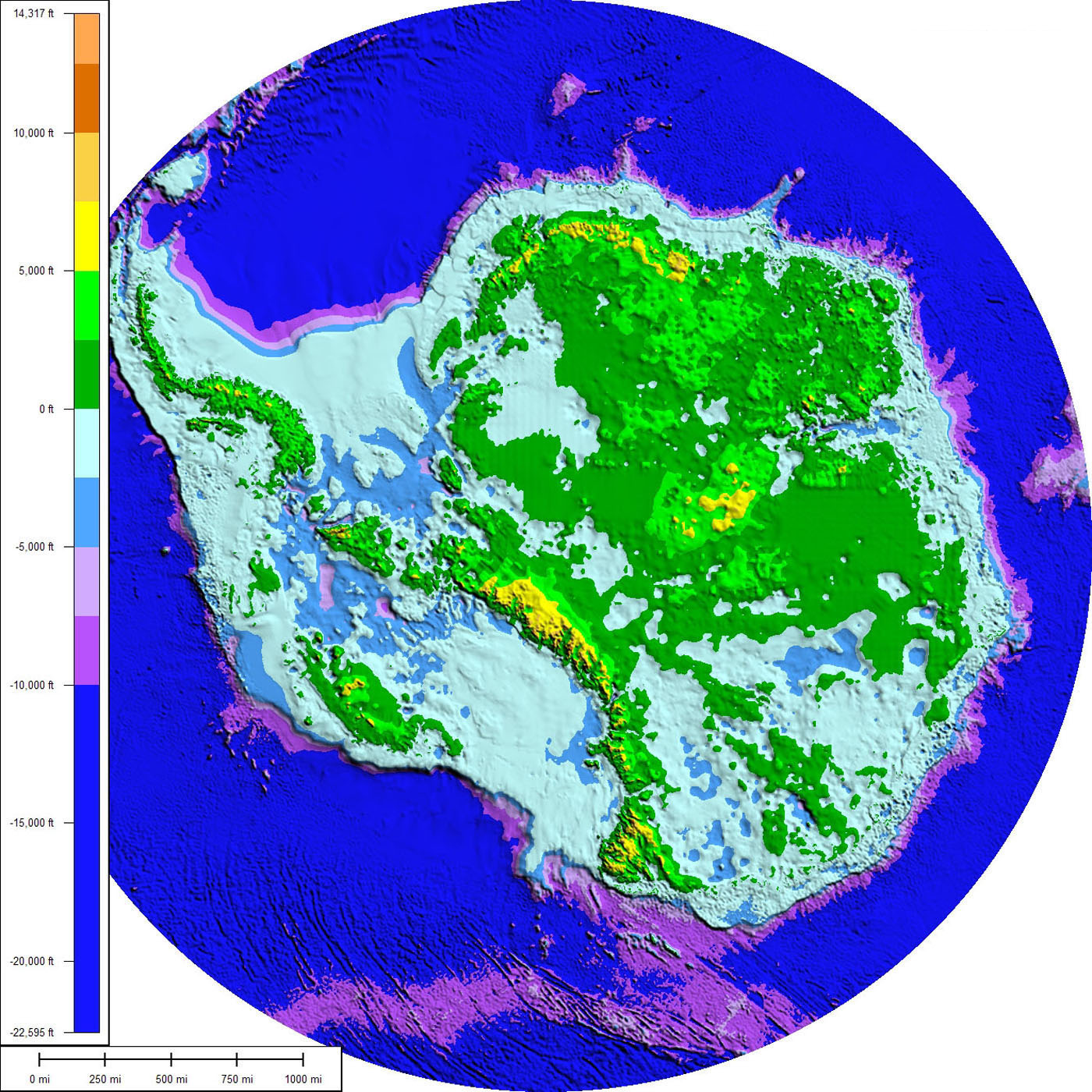
Mapping a lost landscape in unprecedented detail
In January 2026, researchers unveiled one of the most detailed maps ever created of Antarctica’s subglacial topography. Using high-resolution satellite data and a technique called ice-flow perturbation analysis, scientists have revealed tens of thousands of previously unknown hills, ridges, deep valleys, canyons, and alpine-style landscapes buried under kilometres of ice.
This is no flat, featureless plain. The hidden terrain includes dramatic mountain ranges, broad plains, and intricate networks that control how ice flows toward the ocean. Understanding this topography is vital: small changes in the shape of the bed can determine whether a glacier stabilises or accelerates toward irreversible retreat.
Drilling into deep time
Perhaps the most profound breakthroughs have come from daring drilling operations that pierce the ice to reach the sediments below.
In early 2026, an international team working on the SWAIS2C project achieved a world record: they drilled through 523 metres of ice at Crary Ice Rise and extracted a 228-metre-long sediment core — the longest ever retrieved from beneath an ice sheet. This “time capsule” contains a geological record spanning roughly the past 23 million years.
Preliminary analysis shows layers of marine mud and fossils indicating periods when the area was an open ocean rather than covered by thick ice. These findings provide direct evidence that the West Antarctic Ice Sheet has retreated significantly in the past during warmer climate phases — offering a sobering analogue for what could happen again as global temperatures rise.
Elsewhere, scientists have recovered ancient ice containing air bubbles and rare gases dating back nearly 6 million years, while other cores reveal surprising patterns: even as the planet cooled millions of years ago, greenhouse gas levels did not drop as sharply as once thought.
Rivers, lakes and volcanoes under the ice
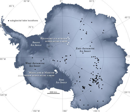
The surprises continue. Researchers have identified or confirmed hundreds of subglacial lakes — some active, periodically draining and refilling like hidden reservoirs. In 2025 alone, satellite data revealed 85 previously unknown active lakes, bringing the total to more than 230. These lakes lubricate the base of the ice sheet, influencing how fast glaciers slide toward the sea.
A catalogue released in 2026 documented 207 subglacial volcanoes hidden beneath the ice, many concentrated in the West Antarctic Rift System. While most are currently dormant, geothermal heat from even modest volcanic activity could contribute to basal melting.
Scientists have also directly observed subglacial watercourses for the first time — hidden rivers flowing beneath the ice — that play a key role in transporting heat and sediment.
Why these hidden worlds matter
These discoveries are transforming our view of Antarctica from a static, frozen wilderness into a dynamic system with a rich, turbulent history. The ancient landscapes — complete with evidence of past forests and river systems 30 million years ago — show how dramatically the continent has changed. The sediment cores act as archives, helping scientists test climate models and understand how much ice loss is already “committed” versus how much we can still influence.
Dr Ed Gasson, a member of the SWAIS2C team, captured the significance: the ability to recover such deep records from the interior of the ice sheet, far from the edges, is unprecedented and will sharpen predictions of future sea-level rise.
Yet the work is fraught with difficulty. Hot-water drilling through hundreds of metres of moving ice is technically challenging; instruments can become trapped, and windows of opportunity are narrow. Each successful borehole feels like opening a door into another world.
As these hidden realms emerge into scientific light, they remind us that Antarctica is not merely a passive victim of climate change. Its buried geology, ancient climates, and subglacial hydrology actively shape the ice sheet’s fate — and, by extension, the coastlines and cities of the world far beyond the polar circle.
The white continent still guards many secrets. But with every new map, core, and measurement, the veil is lifting — revealing a planet that has changed profoundly in the past, and one that continues to change today.