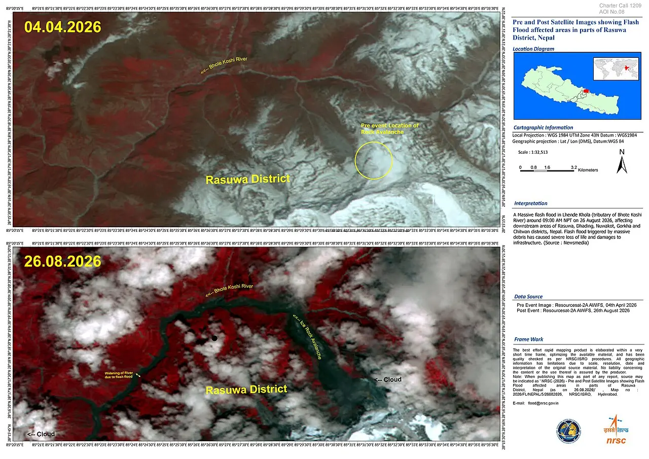
In the steep valleys of northern Nepal, the Bhote Koshi and Trishuli rivers usually announce their moods with the monsoon. On the morning of 26th August they did not.
At roughly 8.37am a mass of ice and rock sheared from a glacier high on the flanks of Langtang Lirung, near the Tibet border. The collapse registered on seismographs as the equivalent of a magnitude-5.2 event. Within minutes a debris-laden surge had roared across the frontier, temporarily dammed a tributary, then broken free. Downstream, water levels jumped by as much as nine metres in half an hour. Bridges vanished. Hydropower intakes filled with sludge. Entire stretches of road, the main overland route between Kathmandu and Lhasa, simply disappeared.
By the afternoon of 28th August the confirmed death toll in Nepal stood above 500 and was still climbing; nearly 2,000 people remained unaccounted for, among them hundreds of foreign tourists and workers. A handful of bodies had been recovered in Tibet and a few more in India. Barrier lakes formed by the debris continued to rise, prompting temporary halts to rescue operations and fresh evacuation orders. The disaster is already Nepal’s deadliest since the 2015 earthquake. Its cause, however, was not tectonic.
Scientists now agree that the immediate trigger was a glacial collapse, an ice-rock avalanche that entrained sediment and water as it fell more than a kilometre to the valley floor. Early satellite images and seismic records show no large pre-existing glacial lake of the sort that produces classic outburst floods. Instead the event belongs to a growing category of high-mountain failures in which thawing permafrost and destabilised ice remove the structural “glue” that once held steep slopes together.
The Himalayas are warming faster than the global average. Nepal has lost roughly a third of its ice volume in three decades; glaciers in the broader Hindu Kush range melted 65% faster in the most recent decade than in the one before. Similar collapses have occurred elsewhere–Chamoli in India in 2021 is the closest parallel–but rarely with such immediate downstream reach.
The geography of damage reveals a more awkward truth. The valleys that channelled the surge are precisely those Nepal has spent the past decade developing. Hydropower plants, operational and under construction, with a combined capacity of several hundred megawatts were knocked offline, including the large Korean-backed Upper Trishuli-1 project nearing completion. Roughly a tenth of national generation capacity was affected at a stroke.
Border trade infrastructure, tourism lodges and the settlements that service both were concentrated along the same narrow corridors. The region had been enjoying an economic upswing: Chinese electric vehicles moving south, pilgrims and trekkers moving north, new transmission lines and concrete bridges. That growth was real. So was the exposure it created.
Nepal’s development model has long rested on two pillars that sit uncomfortably with a thawing cryosphere. The first is hydropower, sold as clean energy for domestic use and eventual export. The second is connectivity–roads, border posts and tourism–along the very rivers that drain the high peaks. Both concentrate people and capital in zones whose physical stability is declining.
Early-warning systems designed for monsoon rainfall or classical glacial-lake outbursts are poorly suited to sudden ice-rock detachments that produce their own seismic signature and leave little time for evacuation. Monitoring networks are sparse; cross-border data sharing remains imperfect.
The immediate response has been workmanlike: thousands of security personnel, helicopters, sniffer dogs and heavy machinery. International agencies have begun to mobilise funds. Reconstruction will cost billions in an economy of roughly $45bn.
The longer-term questions are harder. Can hydropower projects be sited and designed for cascading cryospheric hazards? Should settlement and tourism be discouraged in the highest-risk corridors even when those corridors offer the best trade routes? How should China and Nepal jointly manage shared river systems when a collapse on one side can inundate the other within the hour?
This was not a freak accident of weather. It was a demonstration that the mountains themselves are becoming less predictable. Other Himalayan states confront the same dangerous mix of rapid glacial retreat, ambitious infrastructure programmes and dense populations concentrated in narrow mountain valleys. Across the Hindu Kush Himalaya, glaciers lost roughly 12 per cent of their area and about 9 per cent of their ice reserves between 1990 and 2020, with the rate of loss accelerating after 2000 as the region warms faster than the global average. Expanding glacial lakes, thawing permafrost and more frequent rock-ice avalanches are raising the risk of sudden floods and debris flows that can travel long distances downstream.
In India the pattern is especially clear in Uttarakhand, Himachal Pradesh, Sikkim and Arunachal Pradesh. Glacial lakes have multiplied and grown rapidly; high-risk lakes now threaten settlements, bridges and roads in several basins. Recent disasters illustrate the stakes: the 2013 Kedarnath floods, the 2021 Chamoli rock-ice avalanche that destroyed the Rishiganga project and heavily damaged the Tapovan-Vishnugad plant, killing more than 200 people, and the 2023 South Lhonak Lake outburst in Sikkim that wrecked the Teesta-III dam and damaged others downstream. Hydropower projects, many of them run-of-river schemes strung along the same steep corridors, continue to expand even though assessments show a large share lie on potential outburst pathways. Towns, worker camps, pilgrimage sites and transport routes cluster in these valleys, amplifying exposure.
Pakistan faces comparable pressures in the upper Indus basin. Glacial retreat and lake formation feed into flood and landslide risks that threaten both communities and major infrastructure. Large schemes such as the Diamer-Basha Dam sit in glaciated terrain marked by unstable moraine slopes and seismic activity. Settlements and roads in the narrow Indus and tributary valleys lie directly in the path of any major failure.
Bhutan, whose economy depends heavily on hydropower exports, shows the same combination. Glacier area has declined sharply and numerous lakes have expanded; modelling indicates that thousands of people, thousands of buildings, hundreds of kilometres of roads and significant farmland could be affected by outburst floods. Large projects such as the Punatsangchhu cascade stand downstream of high-risk lakes, prompting stronger design requirements for geohazard assessment. As elsewhere, population and infrastructure remain concentrated in the river valleys that would channel any sudden surge.
The result is a regional vulnerability in which cryospheric instability, energy and transport ambitions, and settlement patterns reinforce one another. Early-warning systems designed mainly for monsoon rainfall struggle to detect rapid ice-rock collapses or lake breaches, while cross-border data sharing remains incomplete.
The flood that arrived in Nepal without rain has already rewritten casualty lists and balance sheets. Its more lasting effect may be to force a recalculation of what “development” means when the ground, and the ice above it, can no longer be trusted to stay put.
The Nepal disaster is less an outlier than a stark illustration of risks shared across the Himalayan arc.